Beaver Creek (Juvenile Monitoring)
Clatskanie River Population
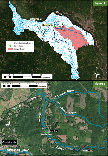
Beaver Creek
Beaver Creek is located northeast of the Clatskanie River and flows into Beaver Slough and then the Columbia River (Figure 1). Historically it is thought Beaver Creek may have supported 300-1,000 Chum Salmon spawners based on estimates of abundance (Parkhurst et al. 1950) expanded by habitat area; the only adult Chum Salmon reported recently was a single individual in Stewart Creek (a tributary) in the last 20 years. Land use in Beaver Creek is rural residential, agriculture, and industrial forest. Suitable spawning gravel exists in the system, but in many areas gravel is mixed with small cobble that is likely larger than that preferred by Chum Salmon (gravels 2 -3cm in diameter). Excess fine sediment, a lack of large woody debris, and channel incision are also observed throughout the low gradient portion of the channel (Alfonse et al. 2017a). A large, impassable falls to upstream anadromous migration is located approximately 6.3 Rkm upstream of the confluence with Stewart Creek and reach of tide. In 2016, a rotary screw trap was installed approximately 3.3 Rkm downstream of Beaver Falls (Figure 2). The trap was installed on March 9th and removed on May 30th.
Literature Cited
Alfonse, B., K. Homel, J. E. Nunnally, and E. Suring. 2017a. Chum Salmon Spawning Habitat Report for the Clatskanie River and Scappoose Creek Populations. Oregon Department of Fish and Wildlife. Clackamas, Oregon. 196 pages.
Parkhurst, Z. E., F. G. Bryant, and R. S. Nielson. 1950. Survey of the Columbia River and its tributaries. Part 3. USFWS Special Scientific Report-Fisheries, No. 36, 103 pages.